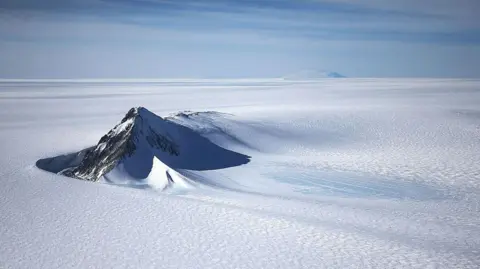
A new map has unmasked the landscape beneath Antarctica's ice in unprecedented detail, something scientists say could greatly enhance our understanding of the frozen white continent.
Researchers used satellite data and the physics of how Antarctica's glaciers move to work out what the continent might look like beneath the ice. They found evidence of thousands of previously undiscovered hills and ridges, and say their maps of some of Antarctica's hidden mountain ranges are clearer than ever before.
While the maps are subject to uncertainties, the researchers believe the new details could shed light on how Antarctica will respond to climate change—and what that means for sea-level rise.
Dr. Helen Ockenden from the University of Grenoble-Alpes, the study's lead author, described the quality of the new maps as akin to shifting from a grainy film to a high-resolution digital image of Antarctica’s features beneath the ice. Existing knowledge about the icy continent's surface has vastly outpaced understanding of its subglacial topography, where much remains to be discovered.
This research represents a significant leap in comprehending how the myriad of mountains, channels, and ridges beneath the ice impact glacial movement and, ultimately, global sea-level changes in an era of climate uncertainty.
The insights garnered from this study are not only pivotal for addressing climate change consequences but also serve as a stepping stone for future explorations in Antarctica’s profound yet concealed geological environment.